
Global Mapper 26.1 Review: GIS Mapping, LiDAR & 3D Analysis
Global Mapper 26.1 Review: GIS Mapping, LiDAR & 3D Analysis
Global Mapper is a geographic information system (GIS) application developed by Blue Marble Geographics. It provides tools for viewing, editing, processing, analyzing, and exporting geographic data. The software is designed for GIS professionals, surveyors, engineers, researchers, and users who work with digital maps and spatial information.
Global Mapper supports a wide range of raster, vector, elevation, and point-cloud datasets. It also includes tools for terrain analysis, coordinate conversion, 3D visualization, geospatial measurement, and LiDAR processing.
This guide explores Global Mapper 26.1, its major features, supported data formats, system requirements, and official installation process.
What Is Global Mapper Used For?
Global Mapper is used to work with geographic information and spatial datasets. It allows users to import different types of map data, view them together, perform measurements, and create useful geographic outputs.
Common applications include:
- GIS data management and mapping.
- Land surveying and terrain analysis.
- Elevation and contour mapping.
- LiDAR point-cloud processing.
- Environmental and geographical research.
- Infrastructure and engineering projects.
- Coordinate conversion and spatial analysis.
- 2D and 3D geographic visualization.
Its combination of data compatibility and processing tools makes it useful for both beginners and experienced GIS professionals.
Key Features of Global Mapper 26.1
1. Extensive GIS File Format Support
Global Mapper supports many common geographic data formats. These include Shapefiles, GeoTIFF, KML, KMZ, GPX, DXF, DWG, CSV, LAS, and LAZ, along with numerous raster and elevation formats.
This makes it easier to combine information from different mapping applications and data providers.
2. Raster and Vector Data Processing
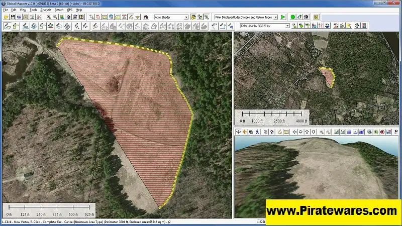
The application can display and process raster imagery and vector datasets in the same workspace.
Users can work with geographic boundaries, roads, points, lines, polygons, satellite imagery, and other spatial information.
3. LiDAR Point Cloud Processing
Global Mapper includes tools for importing, viewing, analyzing, and classifying LiDAR point clouds.
Users can inspect elevation information, work with point classifications, and create useful terrain-related outputs. Advanced processing capabilities depend on the selected license edition.
4. 3D Terrain Visualization
The 3D viewer provides a way to examine terrain and geographic datasets from different perspectives.
Users can explore elevation models, visualize terrain features, and better understand the spatial relationships between geographic objects.
5. Elevation and Terrain Analysis
Global Mapper includes tools for working with elevation datasets and generating terrain-related information.
Common tasks include:
- Creating elevation profiles.
- Generating contour lines.
- Calculating terrain measurements.
- Analyzing slopes and terrain characteristics.
- Performing cut-and-fill volume calculations.
- Creating elevation models from supported datasets.
6. Distance and Area Measurement
The software provides measurement tools for calculating distances, areas, and other spatial properties.
These capabilities are useful in surveying, land management, construction planning, and geographic research.
7. Coordinate Systems and Projection Support
Global Mapper supports coordinate systems and projection management. Users can work with different spatial reference systems and convert geographic information when required.
This is especially useful when combining datasets collected from different sources.
8. Geocoding and Address Search
The application includes tools for locating geographic information through address and coordinate searches.
Some online data and geocoding functions require an internet connection.
9. Scripting and Automation
Global Mapper supports scripting to automate repetitive GIS tasks.
Scripts can help users process multiple files, perform data conversions, and repeat common operations more efficiently.
10. Import and Export Tools
Users can import supported geographic datasets, modify them, and export results into compatible formats.
The available import and export options can depend on the format and license edition.
What’s New in Global Mapper 26.1?
Global Mapper 26.1 includes improvements across several areas of the software.
Notable changes documented by Blue Marble Geographics include:
- Improvements to LiDAR quality-control tools.
- Additional manual point-cloud classification options.
- Improved automatic powerline classification.
- Enhanced processing for large point-cloud datasets.
- New color harmonization options in Pixels to Points.
- Improvements to vehicle detection in the Global Mapper Insight and Learning Engine.
- Better handling of certain LiDAR export and classification issues.
- Additional SDK functionality for loading vector data from WKT strings.
Some of these capabilities are edition-specific, particularly features marked for Global Mapper Professional.
Version note: The supplied post title mentions build 26.1.1.031125. The official documentation confirms the Global Mapper v26.1 release family, but this exact build identifier should not be presented as the latest version without matching official release documentation.
Global Mapper Supported File Formats
Global Mapper supports a broad selection of geographic data formats.
| Data category | Examples |
|---|---|
| Vector | SHP, DXF, DWG, GML |
| Raster | TIFF, GeoTIFF, JPG, PNG |
| Elevation | DEM, DTED, SRTM |
| GPS data | GPX, KML, KMZ |
| LiDAR | LAS, LAZ |
| Text data | CSV, TXT, XYZ |
| 3D data | OBJ, 3DS, selected 3D formats |
Some formats and export functions require Advanced or Professional licensing. Check the official supported-format documentation before planning a specific workflow.
Global Mapper System Requirements
The official requirements currently published for Global Mapper desktop list Windows 11 as the supported operating system.
| Component | Minimum | Recommended |
|---|---|---|
| Operating system | Windows 11 | Windows 11 |
| Processor | Intel 8th generation or comparable | Recent high-performance multi-core CPU |
| RAM | 8 GB | 16 GB |
| Storage | 1.5 GB SSD or HDD | SSD with sufficient data storage |
| Graphics | OpenGL 4.5 support | NVIDIA RTX 20 series or comparable GPU |
Some advanced operations need more resources. For example, Pixels to Points processing requires Global Mapper Professional and has higher memory recommendations.
Large geographic datasets and LiDAR projects can also require considerably more storage and memory than basic mapping tasks.
How to Download and Install Global Mapper
For a legitimate installation, use the official Blue Marble Geographics website.
- Visit the official Global Mapper download page.
- Select the available Global Mapper desktop installer.
- Download the appropriate 64-bit Windows installation package.
- Locate the downloaded installer on your computer.
- Run the installer with an administrator account.
- Follow the installation wizard.
- Launch Global Mapper after installation.
- Use the official trial or purchased licensing process to activate the application.
The developer provides a free trial option, allowing users to evaluate the software before purchasing a license.
Do not use unofficial activation keys, modified installers, or license bypass tools.
Global Mapper License Editions
Global Mapper is offered in different licensing editions to accommodate different workflows.
The main desktop editions include:
- Standard: Core GIS mapping, data viewing, editing, and processing capabilities.
- Professional: Additional advanced tools, including specialized point-cloud and photogrammetry workflows.
- Advanced: Additional specialized capabilities for users who require advanced processing and automation features.
Available functions depend on the license. Check the official product and licensing pages for the latest edition comparison and pricing.
Frequently Asked Questions
1. What is Global Mapper used for?
Global Mapper is a GIS application used for mapping, spatial data processing, terrain analysis, LiDAR processing, geographic measurements, and 3D visualization.
2. Is Global Mapper free?
Global Mapper offers a free trial, but continued access to licensed features requires an appropriate commercial license.
3. Does Global Mapper support LiDAR data?
Yes. It supports common LiDAR formats such as LAS and LAZ and provides tools for point-cloud viewing, classification, and processing.
4. Can Global Mapper open KML and KMZ files?
Yes. Global Mapper supports importing KML and KMZ datasets and provides compatible export functionality depending on the selected license.
5. Does Global Mapper support Windows 11?
Yes. Windows 11 is listed in the official desktop system requirements.
6. Is Global Mapper available for Mac?
The desktop version discussed in this guide is designed for Windows. Do not assume that the Windows installer runs natively on macOS.
7. What is the difference between Global Mapper Standard and Professional?
Professional includes additional advanced processing capabilities beyond the Standard edition. Users should compare the official edition features before selecting a license.
8. Can Global Mapper process large point clouds?
Yes. It includes LiDAR and point-cloud tools designed for large geographic datasets. Processing performance depends on hardware, dataset size, and the selected license.
9. Does Global Mapper require an internet connection?
The application can run without an internet connection, but certain online features, including online activation and access to online datasets, require connectivity.
Final Thoughts
Global Mapper is a versatile GIS application for working with geographic datasets, terrain information, raster imagery, vector layers, and LiDAR point clouds.
Its extensive file-format support, 3D visualization, measurement tools, and spatial analysis capabilities make it useful for professionals and researchers who regularly work with geographic information.
Before installing the software, review the official system requirements and compare the available license editions to make sure the application supports your intended workflow.
Official Resources:
- Official website: https://www.bluemarblegeo.com/global-mapper/
- Official downloads: https://www.bluemarblegeo.com/global-mapper-download/
- Official release notes: https://support.globalmapper.com/hc/en-us/articles/54345697393556-Release-Notes-Versions-20-27
- System requirements: https://support.globalmapper.com/hc/en-us/articles/53119824311316-System-Requirements
- Supported file formats: https://support.globalmapper.com/hc/en-us/articles/53119699059604-Supported-File-Formats


Recent Comments